Enhance Drone Photos Using Aerial Editing
Enhance Your Property's Visual Appeal with Aerial NOTATION AND EDITING

In real estate, the act of taking, processing, and using aerial images and videos to promote properties is known as aerial editing. The popularity of this method can be attributed to its ability to highlight elements that may not be as noticeable from ground-level photography by showcasing properties from unusual perspectives. This is a thorough overview of aerial editing in real estate:
What is Aerial Editing?
Aerial editing involves using drones or other aerial photography equipment to take pictures and films from above. The images are then modified to improve their quality and draw attention to particular aspects of the property.
Benefits of Aerial Editing in Real Estate
Improved home Presentation: Aerial photos offer a thorough perspective of the home and its surroundings, helping prospective purchasers better comprehend the design and characteristics.
Showcasing Important Elements: It is beneficial to highlight expansive homes, scenic scenery, close-by conveniences, and neighborhood allure.
Better Marketing: Exceptional aerial photography can draw attention to real estate listings and accelerate transactions.
TYPES OF AERIAL EDITING WE DO
Aerial Color Fade

Aerial Color Fade
Ensure your property captures attention and doesn't blend into the background.
Opt for our Aerial Color Fade feature, designed to make your listing truly remarkable and provide potential buyers with a comprehensive view of the entire property. With this option, your marketed property maintains its natural vibrancy while neighboring homes gracefully transition into captivating black-and-white tones. Stand out from the competition and present your property visually strikingly with Aerial Color Fade.
Aerial Drop Pins

Aerial Drop Pins
Highlight the Desirable Location of Your Home with Aerial Drop Pins
Give potential buyers a clear understanding of the incredible location of your home using our innovative Aerial Drop Pin feature. Our expert team at Real Estate Photographer Pro, LLC will accurately mark important local landmarks such as schools, shops, and attractions, enabling buyers to visualize the convenience and appeal of the surrounding area. With aerial drop pins, you can effectively showcase the advantageous location of your property and make a compelling case for its desirability.
Aerial Single Lot Highlight

Aerial Single Lot Highlight
Accentuate Your Property or Land Parcel with Aerial Single Lot Highlight
Elevate the visibility of your property or land parcel by adding a vibrant colored outline around its boundaries. With the Aerial Single Lot Highlight feature, we will select the color that best suits your needs, and our team of skilled editors will meticulously apply it. By incorporating this eye-catching feature, you can effectively draw attention to the specific boundaries of your property, making it stand out and leaving a lasting impression on potential buyers. Let us enhance your listing with Aerial Single Lot Highlight and showcase your property in a visually striking manner.
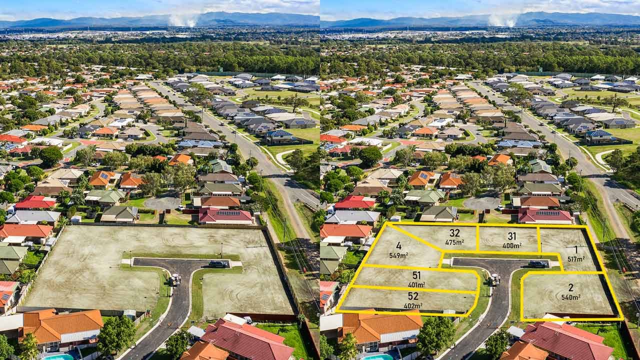
Aerial Multiple Lot Highlight

Aerial Multiple Lot Highlight
Clearly Showcase Multiple Lot Boundaries with Aerial Multiple Lot Highlight
Present the boundaries of multiple lots within a land parcel in a visually appealing and professional manner with our Aerial Multiple Lot Highlight feature. Utilize various colors and overlay styles to differentiate distinctly between different properties, ensuring a clear and attractive display. Our expert team will skillfully incorporate these elements, providing a comprehensive visual representation of the individual lots within the parcel. Enhance your listing with this powerful tool, allowing potential buyers to easily understand the layout and potential of the various properties within the land. With Aerial Multiple Lot Highlight, you can showcase your land parcel with clarity, attractiveness, and professionalism.
Aerial Development Site Plan
Aerial Development Site Plan
Create a Comprehensive Aerial Development Site Plan
Elevate the visualization of your development project with our Aerial Development Site Plan service. Combining an aerial photo with a professionally drawn CAD-based site plan provides buyers with a clear and comprehensive view of the development site.
Our expert team overlaps the existing land by incorporating outlines of roads, lot boundaries, and other site features. This powerful tool allows potential buyers to grasp the layout and potential of the development fully. Submit your project under Development Site Plans in your dashboard. Let us create a detailed and professionally crafted Aerial Development Site Plan that will enhance your listing and attract potential buyers.
Marketing Video with Animated pop-up AERIAL notations and Motion graphics
Enhance Your Marketing Videos with Animated Pop-Up Notations and Motion Graphics
Video marketing is a powerful tool for raising awareness, driving engagement, and boosting sales. As an integral part of digital marketing, it intertwines with content marketing to deliver impactful messages. At our company, we have a team of skilled animators and videographers dedicated to providing you with stunning animation and video content tailored to your specific needs.
Our Motion Designers excel at transforming graphics, text, and illustrations into a seamless and captivating story. By incorporating animated pop-up notations and motion graphics into your marketing videos, we bring an extra layer of dynamism and visual appeal. While this may require specialized expertise and careful planning compared to static assets, the end result is worth it.
Once your brand identity is "set in motion" and the right creative team is in place, you can leverage characters, sounds, music, animated logos, visual effects, and templates to efficiently produce videos that resonate with your audience, all at scale.
Elevate your marketing efforts with our animated pop-up notations and motion graphics, and let your videos truly stand out in the digital landscape.
More Marketing Video Examples - https://www.realestatephotographerpro.com/real-estate-marketing-videos
Enhance Drone Photos USING Aerial Notes Video: AN Overview
Advantages of marking aerial notations on drone photos

Spatial Reference: Aerial notations help establish a spatial reference within the photo, allowing viewers to understand the relative location and scale of objects or features. By marking landmarks, roads, buildings, or other geographical elements, it becomes easier to comprehend the layout and context of the area.
Communication and Documentation: Aerial notations serve as a visual means of communication and documentation. By adding labels, arrows, or symbols to highlight specific points of interest, you can effectively convey information to others, such as colleagues, clients, or collaborators. It becomes simpler to share insights, observations, or instructions related to the captured aerial view.
Data Visualization: Aerial notations can enhance the visualization of data captured by the drone. By overlaying relevant information, such as GPS coordinates, elevation, or sensor readings, onto the photo, you can create a comprehensive visual representation. This can be particularly valuable for scientific research, environmental monitoring, urban planning, or surveying projects.
Planning and Analysis: When conducting surveys, inspections, or assessments using drone imagery, aerial notations facilitate planning and analysis. By marking areas of interest, potential issues, or specific features, you can effectively plan future actions or analyze the current situation. Aerial notations can help identify patterns, trends, or anomalies that might not be immediately apparent in the raw imagery.
Educational Purposes: Aerial notations can be useful in educational settings. They provide an interactive and engaging way to teach about geography, urban development, environmental changes, or any subject matter related to the captured scenes. Students can easily understand and grasp information when annotations are added to the drone photos.
Legal and Regulatory Compliance: In certain industries or applications, aerial notations can play a role in legal or regulatory compliance. By marking boundaries, restricted areas, or safety zones, drone operators can ensure adherence to specific rules and regulations. Aerial notations can help prevent unauthorized access, ensure safety, or demonstrate compliance during inspections or audits.
Overall, adding aerial notations to drone photos enhances their clarity, interpretability, and utility. They facilitate effective communication, analysis, and understanding of the captured aerial views, benefiting various industries and applications.
Aerial Editing: Frequently Asked Questions
-
Aerial editing involves taking and enhancing aerial images and videos of real estate sites, typically with the help of drones, in order to produce top-notch marketing materials.
-
Aerial editing offers a distinctive viewpoint on houses, highlighting aspects that are hidden from view from the ground, such as landscaping, layout, and adjacent locations. This gives prospective purchasers a thorough overview of the property.
-
The property's size, the shoot's length, the editing's difficulty, and the professional's fees are some of the variables that affect the cost. It may be in the neighborhood of several hundred to several thousand dollars.
-
Yes, there are laws that control the use of drones. These laws include getting the required permissions, staying out of no-fly zones, and abiding by safety standards established by aviation authorities, such the Federal Aviation Administration (FAA) in the United States.
-
By showcasing important characteristics, producing visually appealing and dynamic photographs and films, and giving prospective buyers a clearer perspective of the property and its surrounds, aerial editing can improve real estate listings.