Aerial Property Notations and Aerial Property Lines: A Comprehensive Guide
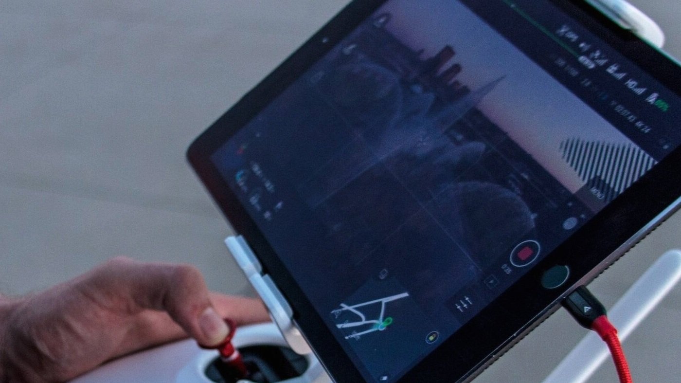
Aerial photography has revolutionized the real estate industry, providing breathtaking perspectives of properties from above. Using drones to capture stunning aerial images has become increasingly popular, offering unique visual experiences for potential buyers.
As a natural extension of drone photography, aerial property notations, and aerial property lines have emerged as essential tools to enhance the value of these images.
In this article, we will delve into the significance of aerial property notations and lines in the context of drone photography and their various applications in the real estate sector.
Aerial Property Notations Examples


The Rise of Drone Photography in Real Estate
Drone photography has quickly gained traction in the real estate industry due to its ability to capture awe-inspiring aerial shots of properties. Real estate agents and photographers can now showcase properties like never before using remotely controlled drones equipped with high-resolution cameras. The bird's-eye view offers a comprehensive understanding of a property's features, including its surroundings, landscaping, and potential for future development.
Advantages of Drone Photography in Real Estate
Stunning Visual Appeal: Drone photography provides captivating, eye-catching images that immediately attract potential buyers. These striking visuals can elevate a property's marketing campaign, increasing its desirability in a competitive market.
Comprehensive Property Showcase: Unlike traditional ground-level photography, drone photography showcases a property's layout, size, and unique features. This gives potential buyers a comprehensive property perspective, boosting their confidence in making informed decisions.
Cost-Effective Alternative: With the advances in drone technology, the cost of aerial photography has become more affordable and accessible. Real estate agents can now opt for professional drone services or even invest in their own equipment to capture stunning aerial shots.
How Aerial Property Notations Enhance Drone Photography
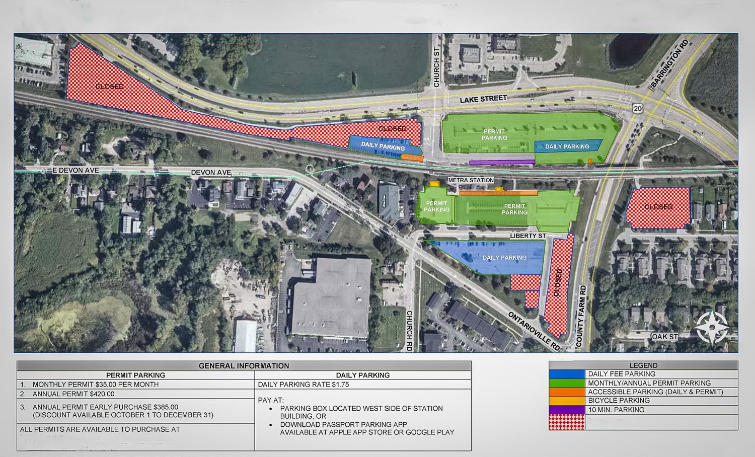
Providing Context and Information: Aerial property notations are invaluable for adding context and information to drone-captured images.
By including labels, symbols, and text on the photographs, viewers can easily identify key features, such as swimming pools, tennis courts, or outdoor recreational areas, enhancing their understanding of the property's offerings.
Showcasing Proximity to Amenities: Real estate agents can use aerial property notations to indicate the property's proximity to nearby amenities, such as schools, parks, shopping centers, or transportation hubs. This information helps potential buyers assess the property's convenience and lifestyle advantages.
Highlighting Potential Development Areas: For properties with substantial land, aerial property notations can outline potential areas for future development or expansion. This can significantly appeal to investors or developers seeking opportunities to maximize the property's potential.
Aerial Property Notations Explanation and Examples
The Role of Aerial Property Lines in Drone Photography
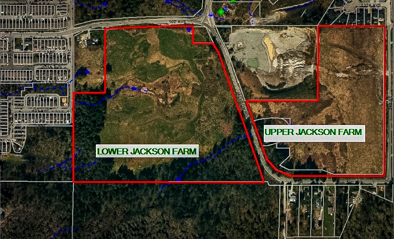
Defining Property Boundaries: Aerial property lines are indispensable in clearly outlining the legal boundaries of a property. By accurately marking these lines on drone-captured images, potential buyers can precisely visualize the property's extent, reducing any confusion or disputes related to its borders.
Evaluating Land Size and Configuration: Aerial property lines assist potential buyers in assessing the property's size, shape, and layout. This is especially crucial for properties with irregular borders or large plots of land, as it allows buyers to evaluate the land's potential use and development possibilities.
Applications in the Real Estate Industry
Engaging Marketing Materials: Aerial photographs with well-defined property notations and lines can be utilized in marketing materials, including online listings, brochures, and social media posts. The visually appealing content captivates potential buyers, increasing their interest in the property.
Virtual Tours and Presentations: Real estate agents can leverage aerial property notations and lines in virtual tours and presentations, guiding potential buyers through the property's features and boundaries in a visually engaging manner.
Legal Documentation and Planning: Aerial photographs with annotated property lines serve as vital legal documentation in cases of boundary disputes or planning applications. They provide concrete evidence of the property's boundaries and can help expedite the legal process.
Aerial Photography: The Unforgettable Gems of Real Estate Marketing
If you've ever browsed through real estate listings, you might have noticed one type of photo that stands out: aerial real estate photographs. These captivating images have a way of grabbing your attention and offering a unique perspective of the property.
In some cases, the aerial pic becomes the Hero Shot, the most spectacular image used as the thumbnail on MLS sites. As agents increasingly use smartphones for real estate photography and 360° Virtual Tours become more common, drone footage has emerged as the final frontier in real estate marketing.
Drone photography, combined with Aerial Edits, presents an ideal way to showcase various features across different types of properties:
Large Rural Properties: For sprawling estates in rural areas, aerial photography provides a bird's-eye view that reveals the property's vastness and highlights its natural beauty. These images help potential buyers appreciate the expanse of land and envision various possibilities for its use.
Fixer-Uppers in Attractive or Convenient Locations: Aerial photographs are perfect for fixer-upper properties located in appealing or convenient areas. The aerial perspective can emphasize the property's proximity to amenities, transportation, and other desirable features.
Undeveloped Land Before Construction: Aerial shots of undeveloped land offer a clear view of its potential. Investors and developers can assess the property's layout and surroundings, making informed decisions about its future development.
Unique Backyards: Homes with exceptional backyards, such as a pool, a well-designed garden, or a beautiful landscape, can truly shine through aerial photography. Aerial images provide a comprehensive view of these features, creating a lasting impression on potential buyers.
Future Renovation or Landscaping Projects: Aerial photographs allow homeowners to envision future renovation or landscaping projects. Whether expanding the house or adding new outdoor amenities, these images offer an invaluable planning tool.
Places with Stunning Location, Location, Location! Aerial photography is ideal for capturing properties in breathtaking surroundings, such as beachfront, mountains, or overlooking scenic landscapes. These images showcase the property's unique selling point, the incredible location.
aerial notations Drone Video
With the accessibility and affordability of drones, aerial photography has become an essential tool in the real estate marketing arsenal. It adds a touch of sophistication to property listings, creating an immersive experience for potential buyers. The bird's-eye view highlights a property's key features and creates an emotional connection with the buyer, making them more likely to explore the listing further.
As the real estate industry evolves, embracing innovative technologies such as aerial photography will undoubtedly become standard practice. Whether for large estates, charming fixer-uppers, or properties with stunning locations, aerial photographs will continue to be the rare eye-catching gems of real estate marketing, captivating buyers and setting properties apart in a crowded market.
Aerial property notations and aerial property lines have become indispensable elements in drone photography and real estate. These enhancements provide valuable context and information to potential buyers, allowing them to make informed decisions about the properties they are considering. Moreover, drone photography offers breathtaking visuals that set properties apart in a competitive market, attracting more interest and engagement from potential buyers.
As the real estate industry continues to embrace technological advancements, the seamless integration of drone photography, aerial property notations, and lines will undoubtedly reshape how properties are marketed, evaluated, and developed.
By leveraging these tools effectively, real estate professionals can elevate their marketing strategies and provide clients with an unparalleled visual experience, ultimately leading to increased success in the dynamic world of real estate sales.